
Wêne:Pont du Gard BLS.jpg

Mezinahiya vê pêşdîtinê: 800 × 309 pîksel. Resolusyonên din: 320 × 124 pîksel | 640 × 247 pîksel | 1024 × 395 pîksel | 1280 × 494 pîksel | 2560 × 988 pîksel | 12.648 × 4882 pîksel.
Dosyeya orjînal (12.648 × 4882 pixel, mezinbûnê data: 18,75 MB, MIME-typ: image/jpeg)
| Ev pel ji Wikimedia Commonsê ye. Agahdariya li ser rûpela danasîna pelê li jêr tê nîşandan. |
|
Danasîn
| Danasîn |
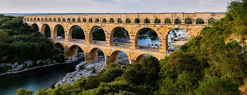
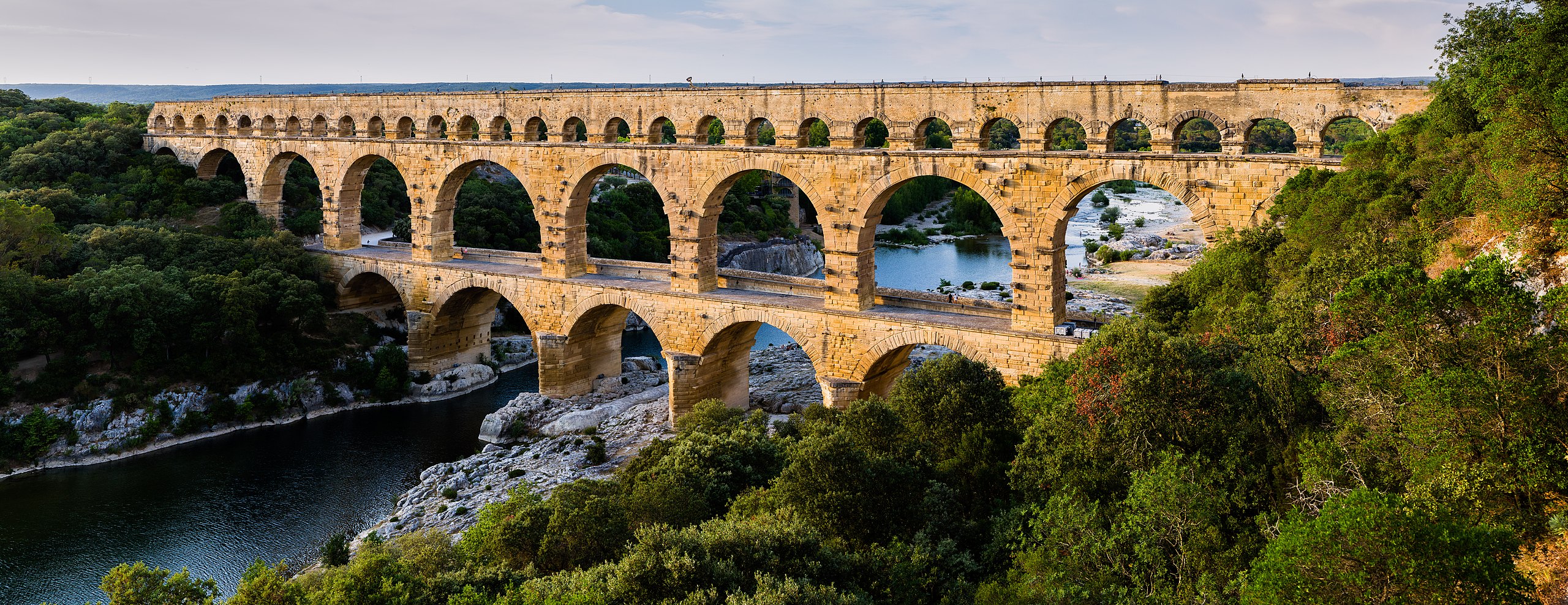
English: Pont du Gard, in Vers-Pont-du-Gard, Gard department, South France. The Pont du Gard is the most famous part of the roman aqueduct which carried water from Uzès to Nîmes until roughly the 9th century when maintenance was abandoned. The monument is 49m high and now 275m long (it was 360m when intact) at its top. It's the highest roman aqueduct, but also one of the best preserved (with the aqueduct of Segovia). The Pont du Gard has been a UNESCO world heritage site since 1985.
Français : Le Pont du Gard, à Vers-Pont-du-Gard, département du Gard, région Languedoc-Roussillon, France. Le Pont du Gard (1er siècle C.E.) est la partie la plus célèbre de l'aqueduc romain qui conduisait l'eau d'Uzès à Nîmes, jusqu'au 9ème siècle où l'on cessa de l'entretenir. Le monument fait 49 mètres de haut et aujourd'hui 275 mètres de long (360 mètres quand il était intact). C'est l'aqueduc roman le plus haut, mais aussi, avec celui de Ségovie, l'un des mieux préservés. Le Pont du Gard est un site du patrimoine mondial de l'humanité de l'UNESCO depuis 1985.
Español: El Pont du Gard (puente del Gard), en Vers-Pont-du-Gard, departamento de Gard, en la región de Languedoc-Rosellón, sur de Francia, es la parte más conocida del acueducto romano que conducía el agua desde Uzès a Nîmes hasta el siglo IX, cuando cesó su actividad. El puente mide 49 metros de alto y 275 metros de largo (360 m cuando se encontraba intacto en la antigüedad). Es el acueducto romano más alto y también, junto al de Segovia, en España, uno de los mejor conservados. El Pont du Gard fue declarado Patrimonio Mundial de la Humanidad por la UNESCO en 1985. |
| Dîrok | |
| Çavkanî | Pont du Gard |
| Xwedî | Benh LIEU SONG (Flickr) |
| Şûnda kamerayê | | Ev wêne û yên din li ser OpenStreetMap |
|---|
Lîsans
I, the copyright holder of this work, hereby publish it under the following license:
Ev pel di bin lîsansa Creative Commons Attribution-Share Alike 3.0 Unported de lîsanskirî ye.
- Tu azad î:
- parve bike – ji bo kopîkirin, belavkirin û weşandina xebatê
- ji bo guhartin û adaptekirina naverokê – ji bo adaptekirina xebatê
- Di bin van mercan de:
- isnad – Divê tu isnadeke maqûl bikî, lînekek pêşkêş bikî ji bo lîsansê, û diyar bikî ku guhartin hatiye kirin an na. Tu dikarî vê yekê bi adilî bi cih bînî, lê ne bi awayê ku wekî lîsansor te an bikaranîna te pejirandibe.
- parvekirinê mîna hev – Ger tu materyalê biguherînî, bizivirînî formeke din, an ava bikî divê beşdariyên xwe di bin eynî lîsansê an lîsansa hevaheng de wekî ya eslî belav bikî.
| Annotations | This image is annotated: View the annotations at Commons |
Dîroka daneyê
Ji bo dîtina guhartoya wê demê bişkoka dîrokê bitikîne.
| Dîrok/Katjimêr | Wêneyê biçûk | Mezinahî | Bikarhêner | Şirove | |
|---|---|---|---|---|---|
| niha | 17:57, 19 hezîran 2014 | 12.648 x 4882 (18,75 MB) | Benh | Verticals. | |
| 10:55, 19 hezîran 2014 | 12.648 x 4771 (18,78 MB) | Benh | User created page with UploadWizard |
Bikaranîna pelê
Ev rûpelên li jêr vê dosyeyê bi kar tînin:
Bikaranîna gerdûnî ya pelê
Ev wîkiyên di rêzê de vê pelê bi kar tînin:
- Bikaranîna di af.wikipedia.org de
- Bikaranîna di ar.wikipedia.org de
- Bikaranîna di ast.wikipedia.org de
- Bikaranîna di ban.wikipedia.org de
- Bikaranîna di bg.wikipedia.org de
- Bikaranîna di bh.wikipedia.org de
- Bikaranîna di bn.wikipedia.org de
- Bikaranîna di bn.wikibooks.org de
- Bikaranîna di bxr.wikipedia.org de
- Bikaranîna di ca.wikipedia.org de
- Bikaranîna di ceb.wikipedia.org de
- Bikaranîna di cs.wikipedia.org de
- Bikaranîna di cy.wikipedia.org de
- Bikaranîna di da.wikipedia.org de
- Bikaranîna di de.wikipedia.org de
- Bikaranîna di de.wikivoyage.org de
Zêdetir bikaranîna global a vê pelê bibîne.