
Wêne:Balkans-political-map-small.png
Versyonekî jê mezintir tune.
Balkans-political-map-small.png (507 × 488 pixel, mezinbûnê data: 12 KB, MIME-typ: image/png)
| Ev pel ji Wikimedia Commonsê ye. Agahdariya li ser rûpela danasîna pelê li jêr tê nîşandan. |
Danasîn

|
This file requires updating. Please see the talk page for more information. In doing so, you could add a timestamp to the file.
|
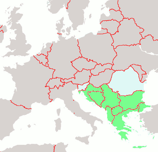
Political map of the Balkans
map of Europe by Brion VIBBER: the Balkans are highlighted in green
| I, the copyright holder of this work, release this work into the public domain. This applies worldwide. In some countries this may not be legally possible; if so: I grant anyone the right to use this work for any purpose, without any conditions, unless such conditions are required by law. |
en:Balkans-political-map-small.png
Dîroka daneyê
Ji bo dîtina guhartoya wê demê bişkoka dîrokê bitikîne.
| Dîrok/Katjimêr | Wêneyê biçûk | Mezinahî | Bikarhêner | Şirove | |
|---|---|---|---|---|---|
| niha | 22:18, 29 çiriya paşîn 2004 | | 507 x 488 (12 KB) | Mschlindwein | Political map of the Balkans |
Bikaranîna pelê
Ev rûpelên li jêr vê dosyeyê bi kar tînin:
Bikaranîna gerdûnî ya pelê
Ev wîkiyên di rêzê de vê pelê bi kar tînin:
- Bikaranîna di arz.wikipedia.org de
- Bikaranîna di as.wikipedia.org de
- Bikaranîna di bat-smg.wikipedia.org de
- Bikaranîna di bn.wikipedia.org de
- Bikaranîna di bs.wikipedia.org de
- Bikaranîna di ckb.wikipedia.org de
- Bikaranîna di cs.wikipedia.org de
- Bikaranîna di de.wikipedia.org de
- Bikaranîna di el.wikipedia.org de
- Bikaranîna di en.wikipedia.org de
- Bikaranîna di eo.wikipedia.org de
- Bikaranîna di it.wikipedia.org de
- Bikaranîna di ja.wikipedia.org de
- Bikaranîna di jv.wikipedia.org de
- Bikaranîna di lad.wikipedia.org de
- Bikaranîna di li.wikipedia.org de
- Bikaranîna di lmo.wikipedia.org de
- Bikaranîna di lt.wikipedia.org de
- Bikaranîna di mzn.wikipedia.org de
- Bikaranîna di nl.wikipedia.org de
- Bikaranîna di oc.wikipedia.org de
- Bikaranîna di pl.wiktionary.org de
- Bikaranîna di sh.wikipedia.org de
- Bikaranîna di sr.wikinews.org de